What China’s World Map Really Looks Like
For many outside China, a Chinese world map is merely a cartographic curiosity—another projection, another way to slice the planet. But for China, a map is never just a map. It is an artifact of historical trauma, a record of territorial reassembly, a statement of geopolitical posture, and a quiet insistence that the world can be seen from more than one center. To understand why China draws the world the way it does, one must treat its map not as a diagram but as a document of national consciousness.
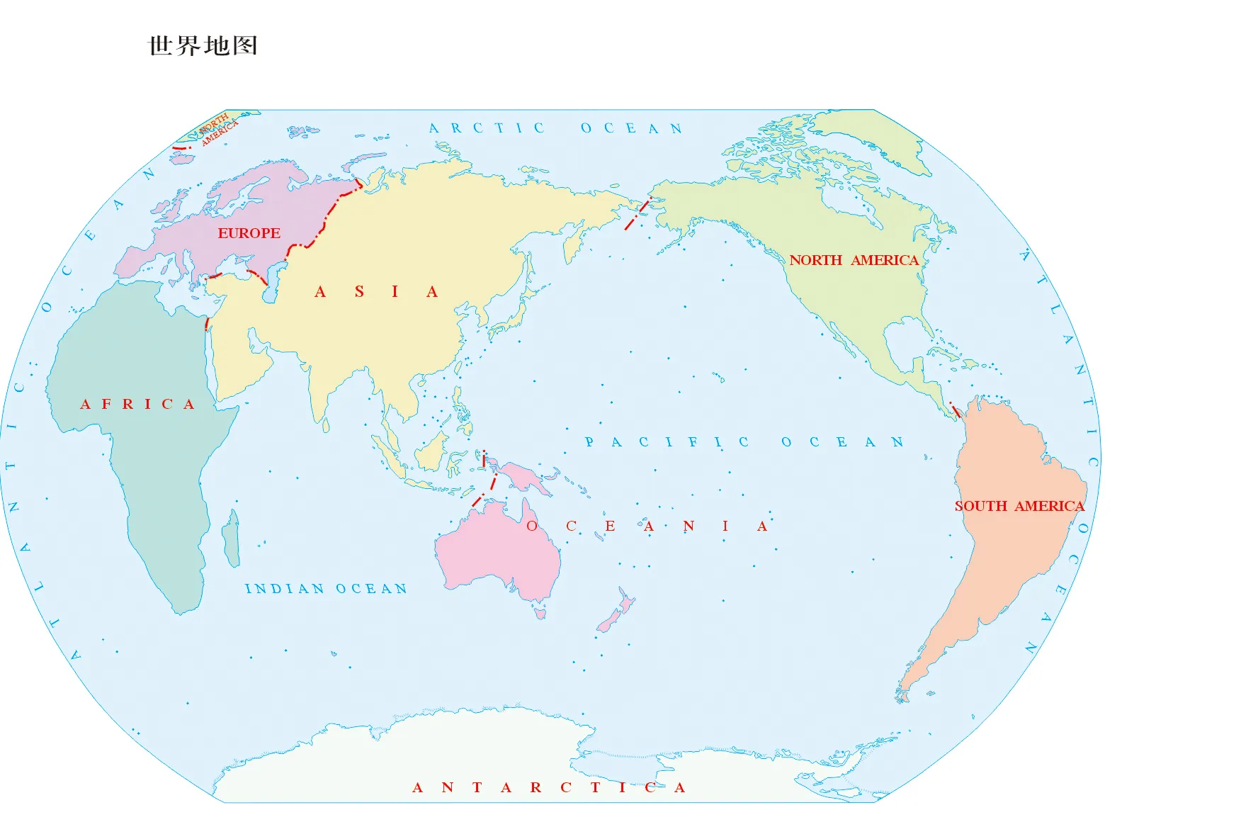
Across the Pacific, Western cartographic tradition places the Atlantic Ocean at the center, creating a world where Europe, Africa, and the Americas frame the primary field of vision. China’s maps reverse this orientation, not to literally place China at the center, but to reflect the sphere through which it experiences threat, exchange, and encounter. In a Chinese atlas, the Pacific occupies the middle, linking East Asia with the Americas and Oceania, while pushing Europe to the map’s far left and Africa to the lower left quadrant. The re-centering may look symbolic to outsiders, but it emerges from a practical orientation shaped by maritime routes, economic strategy, and security anxiety. Geography is destiny—but so is the memory of how geography has been violated, defended, and reclaimed.
The most important thing to understand is this: China’s contemporary world map is not simply the product of projection techniques or state propaganda. It is the spatial expression of a civilization that sees borders not as static lines but as scars and achievements, as the hard-earned perimeter of a world that has repeatedly fallen apart and been rebuilt. To read China’s map is to read its past—and its imagined future.
I. A Story of Borders That Once Collapsed
Few modern states have experienced as many dramatic contractions and expansions of territory as China. Across two millennia, imperial dynasties built borders that extended across deserts, jungles, Himalayan passes, and river basins—only to watch them fracture during invasions, civil wars, and dynastic collapses. For China, borders were never guaranteed. They were obligations.
The 19th century, remembered in China as the “century of humiliation,” left the deepest imprint. Land was carved away through unequal treaties; islands were taken; spheres of influence partitioned the country. That trauma reshaped Chinese political psychology: never again should geography be negotiable.
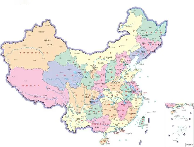
This sentiment is not rhetorical flourish; it is a governing principle. When modern Chinese maps show every claimed territory—Taiwan, the South China Sea, the entirety of Tibet and Xinjiang, disputed Himalayan regions—they are not merely following government decree. They are asserting a historical logic: that the current map is a restoration of what was once lost, a re-stitching of the national fabric torn during its weakest moment.
To the Chinese political mind, borders do not simply define the state—they protect the continuity of civilization. That legacy drives a cartographic conservatism far stronger than in most Western states. What others see as disputes, China often sees as corrections.
This is why a Chinese map is drawn with remarkable uniformity across publishers: it is not an arena for interpretation.
II. The Pacific Window: A Different Orientation of the World
Western atlases treat the Atlantic as the axis of global traffic, echoing centuries of European colonial expansion and transatlantic commerce. China’s map ignores that tradition. Its center of gravity lies to the east, where its ports open to global markets, where its rising navy deploys, and where its strategic fears converge.
The Pacific-centered map, common across East Asia, reorganizes global relationships:
● The United States suddenly feels closer—Los Angeles and Shanghai face each other across a single ocean.
● Southeast Asia sits along China’s maritime lifeline rather than at the edges of the map.
● Australia becomes a northern neighbor rather than a distant southern continent.
This view reflects China’s 21st-century economic metabolism. Most of its trade routes, energy imports, and technology supply chains cross the Pacific or the South China Sea. Threats do too: U.S. naval power, Japanese and Australian alliances, and chokepoints like the Strait of Malacca. Seen through this lens, China’s map is not an assertion of centrality—it is a map of vulnerability.
The Pacific orientation also quietly reveals Beijing’s strategic imagination. A nation that thinks across the Pacific sees itself in direct conversation—and competition—with the United States. Its future, like America’s, runs eastward.
III. The South China Sea: A Cartographic Flashpoint
To Western eyes, the nine-dash line is a claim; to Chinese eyes, it is a statement of identity. The South China Sea occupies an exaggerated visual presence in Chinese maps not because of cartographic distortion, but because it is central to China’s sense of maritime destiny. Historically, Chinese maritime activity did not produce large seafaring empires, but coastal regions were vital to trade and vulnerability. Pirates, invaders, and colonial powers entered through the sea. And today, so does energy.
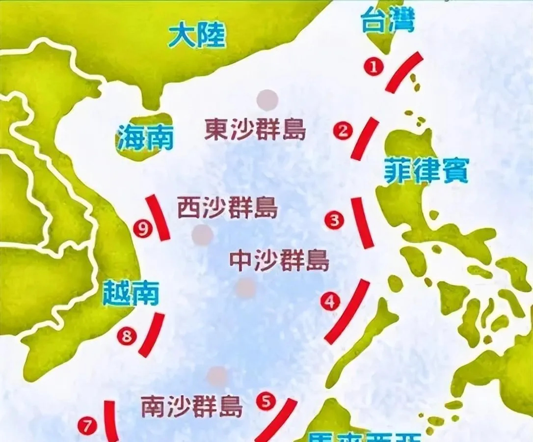
Nearly 60 percent of China’s oil imports and a third of its total trade flow through these waters. When China looks at the South China Sea on its maps, it sees not just maritime territory, but the economic throat through which its lifeblood flows.
This explains Beijing’s insistence on heavy shading, detailed labeling, and explicit boundary markings on every map. It is not merely national pride; it is strategic self-preservation.
The West reads the nine-dash line as expansive ambition. China reads it as defensive depth. These narratives collide in the cartographic space long before they collide at sea.
IV. Xinjiang, Tibet, and the Geography of Civilizational Survival
Every great power has geographic pressure points—regions whose loss would fatally compromise national integrity. For China, these are Xinjiang and Tibet. Their presence on the map is not just administrative; it is existential.
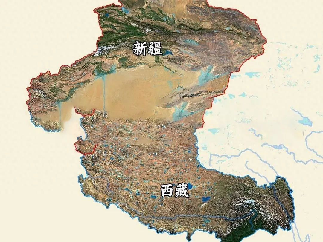
Xinjiang links China to Central Asia, Russia, and the Middle East. It contains vast mineral and energy resources and provides strategic buffer territory. To the Chinese state, its deserts and mountains are walls against historical invaders and ideological infiltration.
Tibet, meanwhile, rests atop the “Third Pole”—the largest reservoir of freshwater outside the Arctic and Antarctic—and straddles the Himalayas. Control of the Tibetan Plateau provides elevation dominance over South Asia and stabilizes China’s river systems.
This is why Chinese maps emphasize these regions with heightened detail: mountain ranges, deserts, and basins are drawn prominently. The terrain is not decorative; it is foundational.
Western maps tend to flatten these regions, reflecting their administrative distance. Chinese maps do the opposite: they magnify their importance as the hinterlands that hold the state together.
V. Digital Maps and the Politics of Coordinates
Foreigners in China often discover that GPS readings are subtly off. Markers drift, locations shift, and routes misalign. These anomalies are not technical glitches—they are the result of China’s encrypted coordinate system, a national security measure designed to obscure precise geospatial data.
China treats geographic information with a sensitivity usually reserved for military intelligence. Mapping providers must use government-approved algorithms; foreign entities cannot freely publish accurate satellite data without state partnership.
The result is a digital environment where maps reflect political boundaries with absolute clarity but physical coordinates with intentional opacity. This inversion—precision in political space, encryption in physical space—reveals China’s priorities. Land is identity; coordinates are vulnerability.
In the West, geography is open-source.
In China, geography is a protected asset.
VI. A Different Mental Map: How Geography is Taught and Remembered
Perhaps the most important difference between Chinese and Western maps lies not in how they are drawn, but in how they are learned.
Chinese students study geography with a focus on:
● provincial boundaries
● river systems that structure civilization
● bottlenecks like the Malacca Strait
● the vulnerabilities of the northeast and southwest frontiers
● the continental scale of China and the ethnic regions within it
This education builds a geopolitical consciousness not common in Western classrooms. Children internalize a map where stability is fragile, borders were once violated, and geography must be guarded. They also grow up seeing China as both ancient and incomplete until fully unified.
This creates a national map that is not simply spatial, but narrative.
The Western mental map—shaped by oceanic exploration, the Atlantic economy, and colonial projection—assumes movement outward. The Chinese mental map—shaped by historical invasions, domestic fragmentation, and continental governance—assumes vigilance inward.
Maps, in other words, reflect civilizations’ differing anxieties.
VII. The Symbolism of Centering
Critics often accuse China of “centering itself” on the world map. But nearly every civilization has done this at some moment in its history. Medieval Europeans placed Jerusalem at the center of the world; Islamic cartographers placed Mecca. Chinese cosmology viewed the Middle Kingdom as the pivot between heaven and earth—not as a hegemon, but as the anchor of harmony.
Modern Chinese maps inherit none of this cosmological symbolism directly, but the cultural memory survives subtly. A map with China near the center is not necessarily an imperial gesture. It is the legacy of a worldview where order begins at home.
Yet this centering does have geopolitical meaning today. By positioning China between the Americas and Eurasia, the map visually asserts a China that is no longer at the periphery of global affairs but at the intersection of competing systems. The map becomes a quiet counter-argument to Western narratives that assume Europe and the United States are natural centers of global structure.
China’s map does not shout. But it shifts the frame.
VIII. The Map as a Proposal for Global Order
Every great power expresses its worldview through cartography. The United States’ maps assume maritime reach and hemispheric defense. Europe’s maps assume a continental mosaic. Russia’s maps assume strategic depth.
China’s map proposes something else: a world not anchored in the North Atlantic, not organized by Cold War blocs, but understood through the Pacific and Eurasian landmass that form China’s strategic theater.
This framing subtly elevates Asia from regional subsystem to global core. It positions China not as a continental power isolated behind mountain ranges, but as a hybrid power—land-based in its security outlook, maritime in its economic lifelines, global in its ambitions.
To read China’s world map is to see its intended future: a civilization repositioning itself not at the margins but within the central flows of global power.
IX. Why This Matters for the Future
Maps do not predict conflict, but they reveal the fault lines along which conflicts may arise. China’s map is not confrontational by design, but it highlights areas where Beijing feels insecure or incomplete:
● the Taiwan Strait
● the South China Sea
● the Himalayan frontier
● maritime chokepoints
● foreign bases encircling the Pacific
Western observers often misinterpret these anxieties as aggressive aspirations. Yet they stem from a historical narrative where geographic weakness led to national collapse. To understand China’s decisions—its naval expansion, its infrastructure push across Eurasia, its uncompromising territorial claims—one must understand how China sees its map: as an unfinished fortress.
When American strategists view China through an Atlantic-centered worldview, they see an expanding maritime power pushing outward. When China views itself through its own map, it sees a nation still securing the fragmented edges of a civilization too often breached.
Two world maps. Two worldviews. One planet.
X. Conclusion: The Cartography of Power
China’s world map is a distilled form of its historical memory and geopolitical philosophy. It reveals a state that views borders as repositories of suffering and legitimacy, that understands the Pacific as its window and its vulnerability, that treats geography as a strategic asset rather than an academic subject.
Above all, China’s map is a reminder that the world does not look the same from every vantage point. Power does not merely reshape territory; it reshapes perspective.
For those who seek to understand China—not as an abstraction, but as a civilization-state navigating the 21st century—its map offers a rare kind of clarity. It shows a nation that has reentered global affairs not to redraw the world in its image, but to redraw its place within a world order whose center of gravity is shifting.
Maps are mirrors.
And China’s map reflects a world where the Pacific is no longer an edge, but a stage.
A world where borders are stories.
A world where geography is memory.
A world where China imagines itself—not triumphant, but restored.